As a reminder, the video is available by following this link: 2022 GTA-GR5 (v17)
Introduction
This article documents the GTA (Grande Traversée des Alpes) via the so-called « classic and integral » route from Lake Geneva (Saint Gingolph in Switzerland) to Nice, which only and strictly follows the GR5.
This great crossing was for me, a hyphen which connects massifs already visited; Mont-Blanc, Beaufortain, Vanoise, Queyras, Mercantour, …
Due to professional constraints, the 21 and a half days of walking were spread over two years, one week in July 2020 and two weeks in July 2021. It was a pleasure to chain the 27,647 m. of elevation gain, the 683 kms, to climb up to 3072 m. at Pointe des Fours.
To the classic GTA-GR5 route, I added 3 variants, for fun:
- The Col du Grand Fond and Vallon du Presset, to greet the team at the Presset refuge and for the view of this magical place,
- The Pointe des Fours to rise to more than 3000 m.,
- The Col de Furfande then the valley of Furfande and its eponymous refuge is a place full of many memories.
This crossing was done in semi-autonomy (refueling every 2-4 days) and essentially solo except for a day and a half during which my son Simon joined me and captured images with a drone.
Motivations
As I say in the video, « Coming out of confinement in July 2020, after 4 months of excessive stress, I felt an immense need for disconnection, nature and solitude. For a long time I had the idea of draw the link between these massifs already visited; Mont-Blanc, Vanoise, Queyra, Mercantour, … The Grande Traversée des Alpes is extraordinary. »
My immense need for disconnection, nature and solitude was largely satisfied and even beyond my expectations.
Loneliness was chosen and not suffered, moreover I was regularly in touch with my loved ones. As Bruno Perrier says in the video, solitude allows for very pleasant meditative moments. In addition, solitude allows great attention and concentration on the present moment offered by the mountain.
Lone Walker Impressions
I lived these 3 weeks (in two « seasons ») in deep immersion with all the components of the mountain and the senses very attentive to the environment.
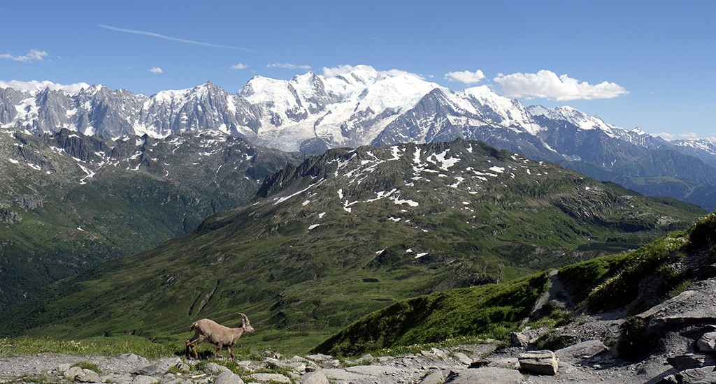
The visual memories come first with landscapes that are both varied and grandiose, the view of the Mont-Blanc massif from the Col d’Anterne is undoubtedly the most majestic and most spectacular. I stopped there for a long time to taste the pleasure of this view so wide on the northern view of the massif and the Mont-Blanc dominating in its center.
During these periods of July, the smells were very present whether they were flowers, especially those of Queyras, pastoral work such as haymaking, or the hinterland of Nice at the end of the crossing.
I was very attentive to the sounds of the mountain, the insects and birds, the streams and torrents, the wind and the rain, the storms, … constitute as many indications on the environment, life and on the mountain. These noises inform the walker who is always more or less on the lookout. I loved reading the landscape in the light of these sounds so rich in diversity and intensity.
Even if I crossed many marmots and a lot of ibexes, the fauna was left to be desired, whether it be, for example, large birds of prey or chamois.
The presence of hikers is very variable, on the common part with the Tour du Mont-Blanc, it is too dense for me and I would almost become a misanthrope. On the other hand in Ubaye, I had to spend a full day meeting only 2-3 people. The exchange with the mountain people who live and work is easy and pleasant, the walker, especially when he is alone, receives a very warm welcome and the conversation starts easily. The long exchange with Rémy Soulas, shepherd, (see the video) was a high point, one of those moments that warms the heart.
The meeting of GTAists and often the occasion of a beautiful exchange, see to be convinced of it the interview of Bruno Perrier who has very right words on the solitary walk.
Physically, the walk was pleasant even if beyond days at 1800 / 2000 m. of positive elevation, the body no longer responds as well. For the two « seasons », the marathon training and the additional preparation for walking allowed me to extend the walks late into the evening. Autonomy also allowed me to adjust the end of each stage to the best compromise between the level of fatigue and the quality of the environment of the stage.
Orientation & track
The GR5 does not present any difficulty in orientation, and I hardly had to consult the 4 topo-guides purchased and taken with me in digital version (tedious work carried out by my wife).
The IGN iPhiGéNie application which embeds all the layers of maps of France with cadastral surveys and images satellites, allowed me to verify that I was where I thought I was. It is a very powerful tool and very economical in battery if you take care to download the maps before departure.
I didn’t upload any traces to my app, I didn’t want to spend my time glued to my app making sure I was in the right place. On several occasions I made a mistake, most often through inattention: discussion with a hiker, immersed in thoughts, misinterpretation of markup, …
On the other hand, I created a track of my crossing with my Garmin Forerunner 935 watch. In addition to the track, the associated application provides a lot of data collected during the walk (see the table of this track below).
Geography (first level)
The path offers great diversity in a classic cycle of the stages of the mountain (from top to bottom):
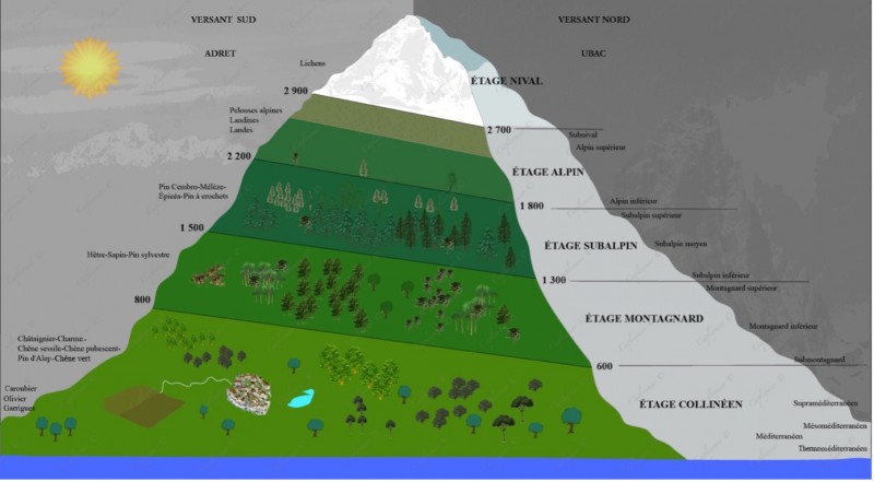
- Nival level: mineral / lichens
- Alpine level: alpine lawns, landines, Landes
- Sub-alpine stage: Cembro-Larch-Spicy pines, Hook pines
- Mountain floor: beech fir, Scots pine
- Hill level: chestnut, hornbeam, sessile-pubescent oak, Aleppo pines, holm oak
- Life in the valleys is hectic and their crossing moderately pleasant and then come the climbs with a clearer environment to become mineral.
The video makes extensive reference to the many passes that punctuate the days.
Haute-Savoie is very inhabited, Vanoise is a magnificent setting, I love Queyras, Ubaye is very calm, Mercantour is demanding and the hinterland of Nice is steeper than I had expected. The nature reserves or national parks: Aiguilles Rouge, Contamines-Montjoie, Vanoise, Mercantour, … are a blessing. Winter sports resorts, even if I am a fan, are like a scarification of the natural environment (eg the passage through Tignes).
I took great pleasure in choosing the highest bivouac site allowed by the morphology of the terrain and my ability to access it at the end of the day, the stage at Lac Saint-Anne is a very good example of this. an exceptional evening.
Accommodation
The accommodation is distributed as follows:
- 9 nights in a tent, a canvas and a floor but no room to reduce weight
- 8 nights under the stars with the over-bag on the ground
- 2 nights in a refuge: Entre le Lac (evening with Fred, a drink from CAF37 and my son), l’Arpont (big storm) and 1 night in a hostel
The nights under the stars have of course given me the best feelings. The celestial vault is superb, sometimes even worryingly dense. The (frequent) awakenings in the middle of the night are always magical moments.
Table of steps
The table of stages is « raw », it is mainly the data provided by the Garmin watch in « Hiking » reading that I started during the first step in the morning and that I stopped in the evening at the stage.
It is important to note that I did not cut through the GR55 in the Vanoise, which is what many hikers who do the GTA do but not by the « classic » GR5 route. This shortcut saves them about 2 days of walking. The so-called classic GTA-GR5 route (see the trek magazine article) goes through Tignes then Val d’Isère and then goes up in the Vanoise to the north (Refuge du Plan du Lac) to go down again to the south (Refuge de l’Arpont ) this North-South descent is sublime.
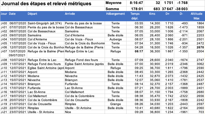
- « Day »: the first stage, started at the beginning of the afternoon in St Gingolph is considered as a half-stage, which makes 21 and a half days in the end
- « Travel time »: travel time calculated by the Garmin watch, this is the time in motion (walking), the break times are therefore counted
- « Kms »: total of the day’s walk
- « D+ »: positive elevation
- « D-« : negative elevation, it should be noted that the subtraction of the two indicates that Lake Geneva is higher than the Mediterranean
Everyone will be able to estimate how they are based on these walking charts, taking into account: a well-marked path, regular breaks, long walks at a fairly slow pace on the ascent and fast on the flats and descent, equipment allowing autonomy (sleeping, food, water, …), photo and video equipment (more than 100 video shots over the entire crossing) and a walker who is approaching 60 years old.
It should be noted that some stages were really long; 12:07 of effective walking to which are added the break times, video recordings, preparation for departure and evening bivouac.
Days that accumulate altitude difference (D+) greater than 2000 m. and more than 30 kms are demanding.
Finally, the least comfortable stage was J-19 with a negative elevation of 2443 m. which caused me a tibial periostitis which made me suffer until the arrival in Nice.
NB: the GPX tracks of each stage are available on request.
Equipment
Synthetic :
- A bag allowing comfortable carrying (for 10 hours of walking) of 15 kg (the weight fluctuated between 10 and 14 kg, walking sticks (one of which also serves as a photo stand), a 3-layer hard-shell that I very often wears Goretex over-trousers (nb: I never bring a poncho but rather a large cut-out garbage bag).
- A tent 1 p. without a bedroom, a 0° comfort down sleeping bag (-5 extreme), an over-bag (for the stars), an inflatable mattress
- 2.5L. water, tablets for purification in case of doubt, freeze-dried for a few days, stove, bowl, food supplies, cereal bars
- Safety: whistle, compass, survival blanket, glacier goggles, 2nd smartphone, pharmacy, Swiss army knife, carabiner, cords, …
- Personal effects including a warm down jacket for the evenings
The photo below gives a complete view of the equipment:
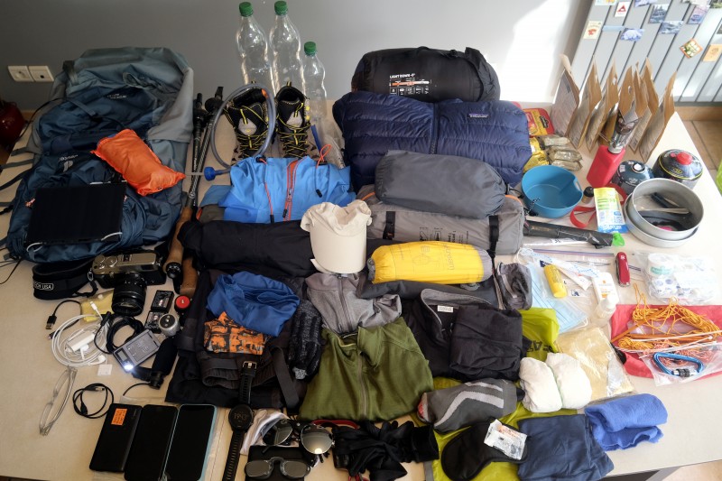
The long version material list : Equipement GTA (xls format).
Some opinions and feedback
- Security: communication, emergency
Although the GR5-GTA crosses largely inhabited regions, communication with a mobile phone is very limited, much less than 50% of the time according to my observations. Even on the emergency services of 15, 17, 18, 112, 114 in multi-operator mode, in the event of an emergency, you should not rely on the telephone to call for help. For the immobilized solitary hiker, there will be no other solution than to wait for a hiker to pass. Which presupposes not having strayed from the path.
One evening when I feared to sprain I worried about the subject. After various research and exchanges with experienced hikers or guides, I bought myself a satellite beacon which includes the possibility of a subscription to a 24/24 emergency service on all continents (except the Arctic and Antarctic). It’s expensive but does security have a price? - Safety: crampons, pilot, rope, …
I don’t think I found the right solution, as the video shows, a modest snowfield can be very dangerous. To go up to the Col des Fours, I found myself halfway up a completely frozen snowfield and my feet were slipping away on the ice… Since I bought a super light ice axe, it weighs 240g., I don’t know if I would take me on a next big crossing, there are also crampons of an equivalent point, to see… - Electric autonomy
It is a very important point to guarantee this autonomy. I had made the choice not to bring paper maps and to digitize the topo-guides. I was autonomous with a solar sensor which permanently supplies a battery (power bank) of 5000 mA or the batteries of the camera. This sensor recharges: the batteries of the camera/video, the smartphone, the watch, the headlamp.
Everything worked well except once when after 3 days with very little sunshine I had to take a break in a refuge to recharge. - Optimizing water transport and feeding
Along the water 😉 I optimized the volume transported, water is very present in the Alps.
The same for food, I had brought too many sachets of freeze-dried food and cereal bars.
By Marc Legroux